About
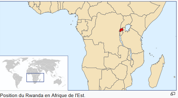
At 26,338 square kilometres (10,169 sq mi), Rwanda is the world’s 149th-largest country. The entire country is at a high altitude. The lowest point is the Rusizi River at 950 metres (3,117 ft) above sea level. Rwanda is in Central/Eastern Africa. It is bordered by the Democratic Republic of the Congo to the west, Uganda to the north, Tanzania to the east, and Burundi to the south. It is a few degrees south of the equator and is landlocked. The capital, Kigali, is near the centre of Rwanda.
The country’s longest river is the Nyabarongo. The Nyabarongo-Kagera eventually drains into Lake Victoria. Rwanda has many lakes, the largest being Lake Kivu. It is one of the twenty deepest lakes in the world. Other sizeable lakes include Burera, Ruhondo, Muhazi, Rweru, and Ihema. Ihema is the largest of a string of lakes in the eastern plains of Akagera National Park.

Lake and volcano in the Virunga Mountains
There are many mountains in central and western Rwanda. The highest peaks are found in the Virunga volcano chain in the northwest. This includes Mount Karisimbi, Rwanda’s highest point, at 4,507 metres (14,787 ft). The centre of the country is mostly rolling hills. The eastern border area has savanna, plains and swamps.
Rwanda has a temperate tropical highland climate. It has lower temperatures than are typical for equatorial countries. This is because of its high elevation. Kigali, in the centre of the country, has a typical daily temperature range between 12 °C (54 °F) and 27 °C (81 °F). There is little change through the year. There are two rainy seasons in the year. The first runs from February to June and the second from September to December. These are separated by two dry seasons. The major one is from June to September, during which there is often no rain at all. There is a shorter and less severe one from December to February.
Biodiversity

Topis in Akagera National Park
In prehistoric times montane forest occupied covered one third of the land of present-day Rwanda. Naturally occurring vegetation is now mostly in the three National Parks, with terraced agriculture in the rest of the country. Nyungwe, the largest remaining forest, has 200 species of tree as well as orchids and begonias. Vegetation in the Volcanoes National Park is mostly bamboo and moorland, with small areas of forest. Akagera has a savanna ecosystem. Here there are mostly acacia. There are several rare or endangered plant species in Akagera, including Markhamia lutea and Eulophia guineensis.
The greatest diversity of large mammals is found in the three National Parks. Akagera has typical savanna animals such as giraffes and elephants, while Volcanoes is home to about one third of the worldwide mountain gorilla population. Nyungwe Forest has thirteen primate species including chimpanzees and Ruwenzori colobus arboreal monkeys. The Ruwenzori colobus move in groups of up to 400, the largest troop size of any primate in Africa.
There are 670 bird species in Rwanda. There is a difference between the east and the west. Nyungwe Forest, in the west, has 280 recorded species. Species include the Ruwenzori Turaco and Handsome Francolin. Eastern Rwanda, by contrast, has savanna birds such as the Black-headed Gonolek and those who live near swamps and lakes, including storks and cranes.